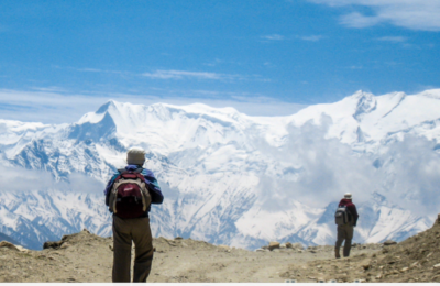
ネパールへ来られたら、ぜひトレッキングに挑戦してみてください。トレッキングは、山の頂上を目指すというものではなく、山の中を歩いて、草花などの自然に触れたり、田園風景を楽しむものです。
ネパールには、多くのトレッキングルートがあります。初心者でも行くことができるルートから、経験者にお勧めのルートなど、様々なルートを用意しております。
普段山に登られていない方でトレッキングで必要なグッズをお持ちでない方は、ネパールでレンタルや中古品を購入することが出来ます。もちろん新品の購入も可能です。グッズがなくても興味があれば、ぜひ検討ください。
トレッキングをするにあたっては、トレッキング許可証が必要になります。行く方面によって、必要なトレッキング許可証が異なりますので、お気軽に当社までお問合せください。
以下ネパール入国管理局でも主な情報を参照することができます。
ネパール入国管理局トッレキング
主なルート
他にも色々なルートがございますが、当社グループ会社「AYUMI TREKS&EXPEDITION」が実施しているルートを記載しております。先ずはエベレスト方面を記載しており、今後徐々に追加していきます。
ルートに関するご質問などは遠慮なく当社までお問合せください。
エベレスト方面
エベレスト方面のトレッキングで知られている、ソル・クーンブ地方は山岳民族シェルパの生活の場です。登山活動の優秀さで知られているシェルパ族は、チベット系民族で、チベット仏教を信仰し、毎年11月にタンポチェ僧院で開かれるマニ・リムドゥは、彼らの最大の宗教行事です。この日に合わせてトレッキングに出かける登山者も多いです。
エベレストに一番近づけるエベレストベースキャンプ及び、カラ・パタールそしてゴーキョピークへのトレッキングは、ルクラまで空路で行くのがよくとられる方法です。1日5便から6便あり、ヘリコプターやチャータ便もご利用できます。
Everest High Passes Trek
Duariation:22days
Overview:
It’s a long and one of the most adventurous treks that includes the very famous Everest Base Camp Trek, for the excellent panorama from Kala Patthar and Everest Base Camp, hard and less attempted Cho La and Renjo La Passes along with sparkling Gokyo Lakes and beautiful Gokyo Valley and less explored but beautiful Thame Valley. This trek starts from the normal and the crowded route to Everest Base Camp. From Everest Base Camp, instead of following the same way back, take another route via the Cho La Pass, Gokyo Valley, Renjo La Pass and Thame Valley, finally meeting the genuine route at Namche Bazaar.
Grade : Moderate Hard
Average walking per day : 5 hrs
Maximum altitude : 5,545 m
Best seasons : Feb-May, Sep-Dec
Type of Trek : Teahouse/Camping
Starting Point : Lukla
Ending Point : Lukla
Everest Circuit Trek
Duration: 20 days
Overview:
Gokyo to Everest Base Camp Trek is one of the most dramatic treks in Nepal, as it combines classic close-up views of Mt. Everest, sparkling Gokyo Lakes, views from Gokyo Ri, a challenging Pass (Cho La) which is rarely attempted by the trekking groups, huge Ngozomba Glacier, Khumbu Glacier, Chang Ri Glacier etc.
Grade : Moderate Hard
Average walking per day : 5 hrs
Maximum altitude : 5,545 m
Best seasons : Feb-May, Sep-Dec
Type of Trek : Teahouse/Camping
Starting Point : Lukla
Ending Point : Lukla
Everest Base Camp Trek
Duration: 17 days
Overview:
This is one of the most popular trekking destinations among others in the Everest region. Every year the number of visitors seems to increase for its wide range of scenic offers. From the tiny airstrip of Lukla, the trail leads through Sherpa villages, forests of fir and rhododendron and across high suspension bridges meeting caravans of Zobkyo (a crossbreed of yak & cow) along the way and from Tengboche the views of Everest, Lhotse, Nuptse and Ama Dablam are astounding. Climbing above the trek line to cross alpine pastures and glacial moraine you eventually reach Base Camp, high on the Khumbu Glacier where colorful expedition tents give a bizarre appearance to this desolate place surrounded by rock, snow and ice.
Grade : Moderate
Average walking per day : 5 hrs
Maximum altitude : 5,545 m
Best seasons : Feb-May, Sep-Dec
Type of Trek : Teahouse/Camping
Starting Point : Lukla
Ending Point : Lukla
ドルパ方面
ドルパ地方は1990年代以降に外国人の立ち入りが許されました。チベット文化の影響を受けているドルパ地域にも近代文化の影響は入ってきておりますが、奥ドルパ方面に行くと、今でも昔ながらの伝統文化を感じることが出来ます。
1ヶ月近くの長い期間のトレッキングが必要ですが、様々な文化に触れることが可能です。
Upper Dolpa Trek
Duration:25 days
Dolpa is a high-altitude, culturally Tibetan, region in the upper part of the Dolpa District of western Nepal, bordered in the north by the Tibet Autonomous Region of China. It is a very isolated area which has been strictly off-limits until only recently, so the traditions and way of life have remained intact. Like Mustang, it has a unique culture; people wear traditional Tibetan-style clothes and jewelry and practice the pre-Buddhist animistic religion of Bon Po. The remote region has preserved its Tibetan culture in relatively pure form, making it attractive to Westerners.
In spite of the near inaccessibility of the region and tourism restrictions for the more remote parts, Dolpa is a popular destination for trekking tourism. The trail passes many gigantic mountain ranges – Annapurna, Dhaulagiri and Kanjirowa, to name a few – and through Lower Dolpa, at one time a small kingdom in its own right. Most villages in Dolpa are removed from the rest of the world to the south by one or more difficult passes. The people that live here number only a few hundred and are among the world’s highest dwellers. The villages in Upper Dolpa are 4,300 m and above.
Grade : Moderate Hard
Average walking per day : 6 hrs
Maximum Altitude : 5,150 m
Best seasons : Mar-Nov
Type of Trek : Camping
Starting Point : Juphal
Ending Point : Juphal
アンナプルナ方面
アンナプルナ地域は、ネパールで最人気のトレッキングの地で、他の地域よりも道路や宿泊施設が整備されており、初心者にもおすすめです。毎日いろいろな角度からヒマラヤを楽しめ、一歩ずつヒマラヤに近づくについて、その迫力に圧倒されます。2月~3月は山の花が咲くシーズンで2000mあたりでは、大輪のシャクナゲが純白の山々に花を添えます。
1~3週間のおすすめトレッキングコースはゴレパニ、カリ・ガンダキ、ジョムソン、アンナプルナ内院があります。
300キロのアンナプルナサーキットは標高の高い山道、トロン峠(5416m)を横切る地域をつないでおり、完走には少なくとも3週間はかかります。
Ghorepani – Poon Hill Trek
Duration: 11 days
Ghorepani-Poon Hill trekking is a colourful short venture into the Annapurna region. This trek, in the Annapurna foothills to the view point on Poon Hill, offers all the best of trekking in Nepal. Enjoy trekking in the spectacular mountain scenery through charming villages inhabited by the Gurungs, Magars, dense rhododendron forests full of birds and deep sub-tropical valleys, all set below the Annapurnas with the picturesque peak of Machhapuchhre dominating the skyline. At the climax of this trek you will climb Poon Hill at dawn to enjoy one of the most spectacular views of the mountains on earth. As the sun touches the snow-capped summits the Himalayan giants, Dhaulagiri (8,167 m) and Annapurna (8,091 m) along with a maze of other peaks, slowly begin to appear, like magic.
Trek Profile:
Grade : Easy
Average walking per day : 5 hrs
Maximum altitude : 3,210 m
Best seasons : Feb-May, Sep-Dec
Type of Trek : Teahouse/Camping
Starting Point : Pokhara
Ending Point : Pokhara
Royal Trek
Duration: 9 days
This short and easy trek got its name as the “Royal Trek” because Prince Charles of Great Britain walked through this route with an entourage of 90 guests, camping followers and staff in 1980′s. This is the best trek for those who want to experience the village life and striking mountain views in a relatively short period of time. Nevertheless, there are no lodge accommodations along this trekking route.
This short trek commencing from Pokhara after driving to Bijaypur Khola, takes on a 4-day loop through the Himalayan foothills ending up at Begnas Lake, offering panoramic views of the Annapurna massif, Machhapuchhre, Dhaulagiri, Manaslu Himal and other surrounding peaks.
Trek Profile:
Grade : Easy
Average walking per day : 4 hrs
Maximum altitude : 2,000 m
Best seasons : Feb-May, Sep-Dec
Type of Trek : Camping
Starting Point : Pokhara
Ending Point : Pokhara
Annapurna Base Camp Trek
Duration: 16 days
This trek combines some of the most spectacular mountain scenery, providing a fascinating insight into the modern hill life of Nepal. This is probably the most ideal trek: exquisite, short and passionate, a direct route into the heart of the Himalaya. The sanctuary is a hidden pocket of meadow, moraine and glacier, ringed by magnificent sheer-walled peaks: the Annapurnas, Gangapurna, Machhapuchhre, Himchuli etc. The trek begins from Pokhara, passing through lowland villages and rice terraces to mountain glaciers. The trail rises nearly 2,000 m in the last 8 km and one needs to plan for acclimatization. The trail is frequently slippery and there’s danger of avalanches in few places. Thus, early spring and winter treks are not likely.
Trek Profile:
Grade : Moderate
Average walking per day : 6 hrs
Maximum altitude : 4,130 m
Best seasons : Feb-May, Sep-Dec
Type of Trek : Teahouse/Camping
Starting Point : Pokhara
Ending Point : Pokhara
Annapurna Circuit Trek
Duration: 22 days
The Annapurna Circuit is renowned as one of the most spectacular trekking routes in the world. As the name says itself, this trail goes on a circuitous route around the entire Annapurna massifs, visiting the Tibet-like country on the northern slopes of the Himalaya and the dramatic Kali Gandaki Gorge. Much of the trek is through lowland country, but there is one high pass, ‘Thorong La’ (5,416 m). The trail over the pass is steep but in good shape and not hard to follow. This is one point of the entire circuit where you really feel you are amidst the mountains. However, you should be aware of altitude sickness and be prepared for weather extremes as the Thorong La is infamous for changing its moods. The pass is usually snowbound and uncrossable from mid-December to mid-April.
The Kali Gandaki Gorge is another spellbinding part of this trip, known to be the world’s deepest river gorge. The trail up to the Jomsom and Upper Mustang actually goes side by side with the river giving company to the lonely trekker and groups something to talk about. Thus, the Annapurna Circuit is an extraordinary trek, truly one of the world’s best.
Trek Profile:
Grade : Moderate
Average walking per day : 6 hrs
Maximum altitude : 5,416 m
Best seasons : Feb-May, Sep-Dec
Type of Trek : Teahouse/Camping
Starting Point : Beshishahar
Ending Point : Pokhara
ムスタン方面
ローと呼ばれるムスタン地方は、ニルギリ(7061m)、トクチェ・ピーク(6920m)、ムクティナート(3749m)、などによって囲まれたまさしく秘境と呼ぶにふさわしい地です。
ムスタンは200キロメートルにわたる狩猟地区で、主に荒野の屋根地帯、深い渓谷、切り立った崖、氷堆積の谷でなっています。果てしない荒野、原始時代の景観、雪を戴いた山頂、壮観な16世紀の僧院、その他多くのユニークな見どころにより、秘境ムスタンは他に比類なき場所となっております。ムスタン王城(ロー・マンタン)は、壁に囲まれた町で、歴史的にムスタン古代政府の首都でした。いまだに5階建ての王宮があり、ジャンパルやタクチェン・ゴンパという仏教僧院で知られています。
ムクティナートはムスタン地方のジョンソンから北東に18キロメートルのところにあり、聖地として巡礼を集めています。ジャナイ・プルニマとラム・ナワミの祭りの期間中は、多くの信者がムクティナート神の参拝に訪れます。
Upper Mustang Trek
Duration: 18 days
Mustang is a rugged mysterious arid and haunting wilderness region set amid a lunar landscape of wind eroded hills and cliffs. It is a part of Dhaulagiri Zone with Jomsom as its headquarters and extends northward onto the Tibetan plateau. Upper Mustang was a lost kingdom of Tibet, and although it is now part of Nepal, traditions remains purely Tibetan in the former Lo Kingdom.
The fabled medieval wall city of Lo Manthang, unofficial capital of Mustang, was forbidden to foreigners until 1992. It remains a controlled region, which very few people visit, a deliberate policy of cultural and environmental preservation. There is a King’s Palace, surrounded by a maze of gompas and private houses all enshrined within the city boundary walls. Unmolested Mustang is frozen in time; it remains one of the ultimate journeys ever likely to be done in one lifetime.
Trek Profile:
Grade : Moderate
Average walking per day : 6 hrs
Maximum altitude : 4,100 m
Best seasons : Mar-Nov
Type of Trek : Camping
Starting Point : Jomsom
Ending Point : Jomsom